Route Name: Kuroto ridge (Kuroto-one 黒戸尾根)
Mountain: Kaikomagatake (甲斐駒ケ岳)
Map sheet: 41 [Yama-to-kougen-chizu (山と高原地図) series]
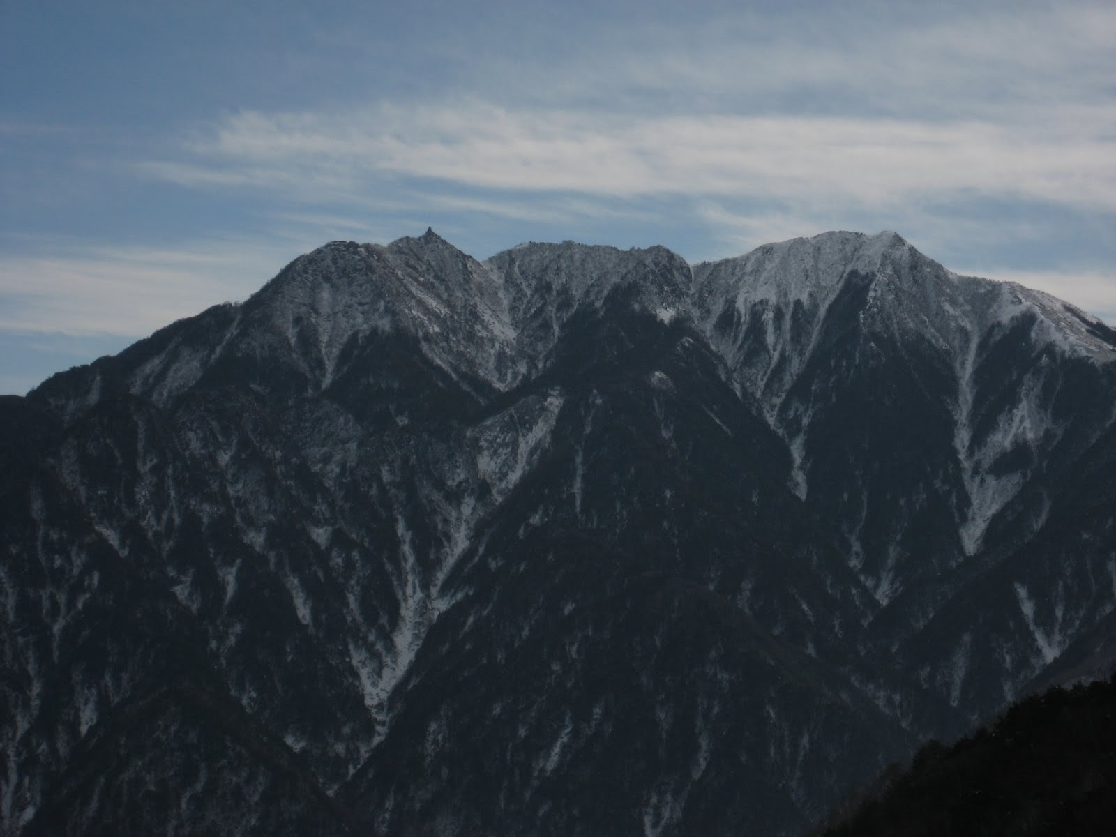
If you’ve ever taken the Chuō Line beyond Nirasaki (韮崎), on your way to Yatsugatake (八ヶ岳) or the North Alps, you will no doubt have noticed the striking mountain on your left at the top end of the South Alps… a giant pyramid, with a deep cleft down the middle of its east face, and a long and beautiful ridgeline extending unbroken all the way from the summit to the valley floor, an alititude gain of about 2400m. The mountain is Kaikomagatake (2967m), and the ridge you’re looking up is the celebrated Kuroto ridge.

Kaikomagatake, or Kaikoma for short, is without doubt one of the finest mountains in Japan. From its summit there is an unbroken 360 panorama that, in my opinion, is unrivalled in this country. The Kuroto ridge is the longest and the hardest of its normal hiking trails, and an absolute must for any dedicated hiker, summer or winter.
Getting there:
If travelling from Tokyo by train, take the earliest Chuō Line train you can from Shinjuku to Nirasaki (韮崎). Right outside the exit of Nirasaki JR station you’ll find the bus stands. From here you need to take a bus to the start of the approach. If you are to make it to the hut on the ridge before dark then you must take the first bus to Shirasu (白須, might also be read Shirosu), which leaves just after 8am. Shirasu bus stop is near a large garden centre, from which you can see Kaikomagatake looming to the southwest. You can get fresh drinking water from a fountain outside this garden centre before you start walking.
Trace the Kuroto ridge down from the summit of Kaikomagatake, and basically aim for the foot of it, via any of the local farming roads that take you in the right direction. After about 50mins of walking you will arrive at Chikukomagatake shrine (竹宇駒ヶ岳神社), a holy site for shugendō religious practice, which is the trailhead for this climb. If you don’t fancy the extra 50mins walking you could just take a taxi from Nirasaki station to the shrine, but this will be very expensive.

Description:
From the shrine, cross the suspension bridge over the river, and follow the path upwards through the initial zigzags.

After about 30mins the path will veer to the left and contour up and round onto the crest of the ridge.

Keep going, and after about 2 hours of map time you will reach a junction where your trail is joined by another approach trail that came up from Yokotekomagatake shrine. You are now on the Kuroto ridge proper. Keep following the path up through the forest, with red paint markers on the trees to show you the right way.

After about 1.5 hours the ridge will begin to narrow until you reach an airy knife-edge section with chains. Be careful crossing this. It is not difficult, but a slip here would be very serious indeed.


After another 15-20 minutes you will reach a small shrine at 2049m. From here on you will begin to encounter ladders fixed on the steep sections.


Keep going for another hour or so and the trail will descend for about 100m to a col. This is the 5th station on the ridge. In the past there was an emergency hut here, the Gogome-goya (五合目小屋). Although it is still marked on some of the hiking maps, this hut is no longer here. Climbers aiming for an ascent of the O-ren-dani ice route used to sleep here the night before their climb, but nowadays a tent or an open bivouac would be necessary.
At the far end of the col you’ll find the longest and steepest ladder on the route, about 20 metres high. Take care up this, especially in your crampons.


For the next hour or so from here the trail goes up and down very steeply, with a lot of ladders and chains to negotiate, some of them quite exposed indeed.

Eventually you will round a corner at about 2400m and arrive at the Shichijodaiichi-goya hut (七丈第一小屋). This is your base for the night. If the main hut is open and operating then you will have to stay here for ¥3500, with unlimited supplies of hot and cold water. The emergency hut about 30m beyond, which is also marked on the maps, will be locked in this case. If not, the emergency hut will be unlocked, and you can stay there for free.
After (hopefully) a good night’s sleep, you will be ready for an early start and the final 500m of ascent to the summit.

The first hour will take you up a steep and rounded hillside to the eighth station, or hachigome (八合目). The views across to the Houousanzan (鳳凰三山) mountains are stunning, with Mt Fuji (富士山) behind in the distance.
From the hachigome you will see the final headwall, and the ridge extending up and through it in a series of giant granite boulders and broken rock features.


The ridge is narrow for a brief section here, and heavily corniced on the left in winter, so stay to the right. The ascent ahead looks improbable, but the path snakes through all this chaos without problems, although there is one short section of chain to get round a corner, involving a slightly high step with some exposure. A bit further on lies the crux of the ridge, a steep gully about 20m in height with a rock step halfway up it. There is a chain hanging down the rock, and there are anchors in the rock wall on your right. It is not difficult, but people have slipped and died from this spot, so prudent climbers will take a length of rope and a few slings to protect the descent of this gully on the way back.
Keep going, with stunning views of the rock wall to your left and the O-ren-dani down to your right.

After another 15-20mins you will make the final approach onto the summit pyramid, where you will find a small shrine and the usual summit markers.

The views from here are second to none, so if conditions allow, get your camera out and make the most of it…


Okay, all you have to do now is reverse the whole 2500m back to the shrine you started from… nobody said it was going to be easy J!
Overall:
A 3-star classic winter ridge hike up the ridgeline of one of the most stunning mountains in Japan, with all the ingredients of a great winter adventure. This route makes the Yatsugatake ridge hike seem like a walk in the park in new shoes. Fukada Kyuya made special reference to it in his book of the 100 finest mountains of Japan (Nihon Hyakumeizan), and for good reason. Go for it…
Great climb! Went after seeing it here looking for mountains with fairly easy winter approaches. Thanks for the info here. Any ideas how to get to senjogadake in the winter by bus if possible?
ReplyDeleteHey, Tony! Thanks for the story. Can I ask your advice please? I want to go this route with friends in May. Do you think it will be possible to pass it in the spring without special climbing equipment?
ReplyDeleteHi Hippy. There will almost certainly still be snow in May, especially in the upper parts of the Kuroto ridge above the hut at the 7th station. You'd be well advised to take crampons and an ice axe with you. Have a great trip!
ReplyDeleteHi Tony - any idea how this is in mid November? ok condition wise?
ReplyDeleteHi Paul. Depending on the year it could be still quite bare in mid-November, or covered in snow. We've had a really wet and cool autumn so far though, and snow has arrived on some mountains even down to about 1700m already, which is quite early, so I'd expect conditions to be quite wintery this November. If you go equipped for snow (crampons and an axe) and find it dry, no problem... but if you go equipped for a trail run and find it covered you'd be unlikely to want to go much further than the 8th station on the ridge. So I'd assume winter for this November. Hope that helps :)
Delete